Trip Report: Backpacking West Coast Trail, Pacific Rim National Park — CAN
Trip Date: August 23–27, 2018
Trip Details
An adventurous foray into the shoreline and coastal forests of West Vancouver Island!
Technically, this was our first international backpacking trip and planning the logistics was quite fun! The West Coast Trail is co-managed by Parks Canada and the Tribes of the First Nations (Huu-ay-aht, Ditidaht and Pacheedaht). While doing research, we noticed most people completed the entire trek, which is about 75 km from North to South or vice versa. Recently, Parks Canada began allowing people to start at the mid-way point: Nitinat Narrows. You can complete the trek going in either direction.
The Parks Canada website has great resources and information on trip planning down to the day-to-day!
Permit: First-come, first-served on Parks Canada website. You must have an account to purchase permits. Permit reservations that year released January 8th, 2018 at 8AM PST. An in-person orientation session was required in order to obtain the actual permits. In 2018, there were two one-hour sessions each day at 8:00AM and 3:30PM.
Getting There:
Flight: We flew from Oakland > Seattle > Victoria International Airport. Since the flight was “international” our luggage was offloaded when we landed, and we needed to grab it to check it in for our next flight. There was a tight time window here but Sus came in clutch with her Global pass, got through security, grabbed our bags, and met us on the other side while we were going through the normal plebeian route. Something to keep in mind if you’re coming from out of country!
Stay: We stayed at Doubletree Hilton. They allowed us to keep our other luggage there while we skipped off on our backpacking trip. We stayed here again for a night after returning.
Shuttle: 5 hours from Victoria Terminal to Nitinat Visitor, a quick 5-minute walk from the hotel. Booked here: http://trailbus.com/west-coast-trail-fares/
Stay: Nitinat Motel, right next to the Visitor Center. A minimal stay, clean with just what we needed for the night. Booked here: https://nitinahtmotel.ca/
Ferry: From the Narrows to the trailhead! Pay for this in cash at the Visitor center.
Trail Length:
Trail length: 33 km. Map
Nitinat Narrows > Pachena Bay
Weather/Conditions: 50–60s F. Sunny/Rainy. Muddy, wet, slippery. Prepare to feel soggy the entire time.
Other Things To Note:
Tides: There are sections of the trail that require you to time the tides. You will obtain a tide chart during orientation with your map. Plan accordingly.
Poop situation: There are outhouses scattered along the trail (available at all campsites) and we didn’t find ourselves needing to use the bathroom in between.
Food Lockers: Metal food lockers are available at campsites.
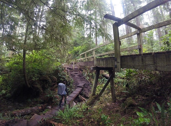
Trail: Assume everything is slippery! There are wooden boardwalks in varying conditions, from newly repaired to dilapidated. Though there is not much elevation change, the terrain can slow you down. It’s very muddy and uneven. Twisted ankles are not uncommon. When walking up a muddy slope, wait for the person in front of you to walk up before starting.
Ladders: There’s a whoooole lot of them. No more than two people on a ladder at a time.
Cable Car: One cable car crossing on our route. Instructions: two people per car max. Keep fingers, hands, and hair away from pulleys. To enter, use the rope to pull the car towards you. Hold the car steady while you load your gear, then carefully enter and stay seated. When crossing the river, let the rope go and gravity will move the car down the rope to the middle of the river. You must then pull the rope hand-over-hand to reach the platform on the other side. Hold the rope so that the car stays flush with the platform, and carefully unload. Do not bounce or sway the car. Never bring it on, or tie it to, the platform.
Buoys: Indicates beach entrance or forest entry onto trail from beach, or campsite
Tsunamis: No idea how often this happens but ostensibly enough to have tsunami warning signs along the trail. If the ground shakes under your feet, or you see the waterline quickly recede from the shore, a tsunami may be coming. Move to higher ground. Follow tsunami evacuation routes.
Bears, cougars, wolves: We didn’t run into any of these but were a hair’s breadth away from bear encounters in front and behind us during the whole trek! That’s just enough adrenaline for me, IMO.
Packing Considerations:
- Gloves: This was a nice to have for me personally and completely OK if you don’t have them. I liked to put them on for ladders to keep my hands clean and to prevent any blistering/splinters.
- Waterproof jacket/pants: Unless you’re very lucky you can pretty much count on it raining during your trip
- Gaiters: Trail is muddy. These kept my pants, top of my boots, and socks clean
- Tarp: Coverage while cooking in the rain
- Hiking Poles: Helped in muddier portions to keep from slipping
- Mosquito repellant
- Cash: Bring enough cash to buy the ferry tickets at least, more if you plan on eating
Costs:
- Airfare: Variable, if applicable
- Hotel lodging (Victoria): Variable
- Nitinat Motel: Variable
- Reservation Fee: $24.50 per person
- Overnight Use Fee: $127.50 per person
- Gordon River Ferry Fee: $20.00 per person
- National Park Entry Permit: $10.00 per person
- Shuttle (from hotel in Victoria to Nitinat Village, roundtrip): $167.00
Day 0: Wednesday, August 27, 2018
After arriving by plane to Victoria, we spent the day exploring the city exchanging currency for the cash only ferry on the trail, and stocking up on gas and last minute items at the MEC store.
Victoria is a cute city with a myriad of food options and boutique stores! I spent a little more money than I anticipated…
Day 1: Thursday, August 28, 2018
We woke up early and sluggishly made our way over to Victoria Terminal to meet the shuttle.
The drive was about five hours long. Knowing my tendency to get motion sickness, I preemptively took Dramamine. I would have been a wreck without it! It was a bumpy ride. I’m glad we decided to take the shuttle instead of driving on our own, though. The road is shared with loggers and you can see them barreling down the narrow lanes without abandon. That would have been terrifying to be next to in a tiny car!
When were dropped off, we headed straight to the motel to drop off our gear.
After, we headed over to the Visitor Center to attend orientation and purchase our ferry tickets.
With some time to kill until the next morning, we walked around the area and hung out at the docks before heading back for dinner.
Food options were scarce, so we planned ahead and decided to eat bagged ramen in the motel room. *Flashback to our Whole Foods trip back in Victoria* We thought it would be a good idea to try the “healthy” bagged ramen and proceeded to immediately regret our decision after the first spoonful. It was so bland! Never again! A thousand grams of sodium per bag and a satchel of spicy mix or nothing!
Before bed, we gathered around Sus’s tiny phone and watched To All The Boys I’ve Loved Before. I imagine I had very nice dreams about Noah Centineo after falling asleep ;).
Day 2: Friday, August 29, 2018
Mileage: 5, Nitinat Narrows to Tsusiat Falls
We met up with other fellow backpackers in the morning by the visitor center and made our way together to the docks. A fifteen minute ferry ride later, we arrived at the trailhead!
The trail wasted no time and immediately entered the forest from the river. From there we were greeted with a sloping wooden walkway and rope “banister”.
The forest opens up to views of the ocean from the cliffside and then drops down onto the beach.
Today was the only day of sunshine we had and we took full advantage. After reaching camp at about 2–3pm, we snagged a nice spot by the cliffside and headed straight to the waterfall to frolic.
This was the closest spot to filter water, the next would be walking up the trail above the waterfall. We were too lazy to do this, so opted to collect water as close to the fall as possible. I was out on this since I couldn’t swim, but a fellow backpacker offered to grab us some! …He failed, lol, but it was still a really nice gesture. Turns out it’s hard to collect water while also wading to stay afloat under a waterfall. Carne got as close as she could and as soon as she started collecting, someone came into the water in their chonies and started bathing. Soap and everything. We tried our best to scrub that from our minds as we collected the last bit of water and brought it back to camp to drink and use for cooking.
We watched the sun slowly dip down and went to bed, content with the levels of vitamin D we absorbed through the day!
Day 3: Saturday, August 30, 2018
Mileage: 6.8, Tsusiat Falls to Darling River
It started to rain as we got up and went about our morning business. This is the end of the sunshine chapter and the beginning of the eternally-feeling-of-sogginess chapter.
A steep set of ladders took us back onto the trail in the forest.
Many ladders later, we made it to the cable car crossing at the edge of Klanawa River. We arrived as the last dude from a large group was getting ready to cross. He offered to help us and we graciously accepted. Carne jumped into the cable car with him and zipped off. We watched her disappear into the tree line and waited for the cable car to come back to us from the other side. Sus and I got in together, touched hands for good luck, and gave the anonymous folks on the other side a signal to start pulling us across.
Once across, we greeted the group who labored to get us over and thanked them for their help. The first thing they asked was whether we were from the States. We confirmed and asked them how they knew. “We assumed you were American because you’re so LOUD!” Lol, well. “Just kidding, it’s because you have REI gear and over in Canada the equivalent is MEC.” Fun fact! For the remainder of the trip we would pass and get passed by this same group. Seeing them made me feel secure :)
We made sure to time our start to give ourselves enough time to pass through the tide crossing at low tide.
We came across a park ranger who told us there was a mama bear with cubs in front of us and to make loud noises to scare them off if we needed to. He was there to make sure no one stayed in that particular area, as the bears seemed to be gravitating to that spot and staying. He wished us luck and sent us on our way.
Once we got to Darling River, we set up camp on the beach. We were probably one of the last to leave in the morning, so we weren’t too surprised to find that most people already arrived and set up shop. We squeezed in next to some other folks after making sure they were OK with having some new neighbors in close quarters.
When dusk arrived, groups of campers started to gather around campfire rings to chat about the day’s hike and relax. We wanted in on this and scoped about the perimeter. Who looked the most inviting? We spotted a pair of backpackers who were on the same ferry as us over on the trailhead and hoped they would let us join them.
Of course, they were extremely nice and offered to share their fire with us. It turned out, it was their first backpacking trip, and we shared stories about our first backpacking experience *triggering Lost Coast memories*. They remembered us from the beginning of the trail and made a comment about how quick our pace was. Then proceeded to serenade us with a song they sang to the Katie Perry, “California Girls” song beat:
🎶 California girls, they’re way ahead of us…Hi-king pants, bikinis on top!🎶
We had such a fun time chatting with them that we were the last to head back to our tents for the night, completely fulfilling the American stereotype of being loud. Apologies! After falling asleep, we all stirred in the middle of the night to the sound of thunder clappers; a warning of the proximity of the bears in our camp. Not knowing what else we could do, we fell right back asleep and woke up in the morning with no bears in sight.
Day 4: Sunday, August 31, 2018
Mileage: 8.6 Darling River to Pachena Bay (West Coast Orientation Center) — End
Once again, one of the last ones to leave again in the morning. Just how do people get ready and pack up so fast?! A couple miles in, a gentleman gave us encouraging words and told us that we were “almost there!” OMG what lies! This guy messed up my mental calculations and getting to the end felt far from being almost there. It wasn’t all bad though, the forest was beautiful and ethereal. A layer of mist hugged the forest floor and wading through it felt dream-like, with the weight of my backpack the only reminder that I was definitely awake! That, and the countless ladders we had to climb up and down.
We took a quick pit stop at the Pachena Point Lighthouse before continuing on our way.
We finally arrived at the end and scampered over to the West Coast Orientation Center to register off-trail. Our names are officially in the system, woohoo! What an accomplishment. As a reward, the sun came out to greet us. We laid out our tent to dry and ate lunch under the warm rays while we waited for our shuttle to arrive.
Note: there are showers, bathrooms, and filtered water here for the public
Once we got back to the hotel in Victoria, we each took lengthy showers to wash off the week’s adventure. With the dirt freshly off our bodies, the bug bites we were “gifted” during the trek revealed themselves. We compared bites while waiting for our takeout order. Carne won by a landslide. She had a huge one on the side of her hip that we called her third butt cheek!
Sleep came easily on the fluffy beds of the hotel :)
Day 5: Monday, September 1, 2018
Flew home filled with smiles and memories (also the aforementioned bug bites). We felt so privileged to have made it out there and thank the First Nations and Parks Canada for doing such a great job with trail maintenance and making sure hikers are prepared and feel safe!
I hope you found this trip report helpful :). As always, looking forward to the next one. Hope to see you out there! Trek on! ❤
